


 (Copy) (Copy)")
It is April of 2018, in front of me — South America, a continent unmatched in terms of natural wealth. But before I move on to admire the wonders of the surrounding lands, I stop for a few days in Santiago, Chile’s capital. My company, VIPERA, has its contractor Jaime here who is a co-owner of nineteen perfumery stores in Santiago, and Polish VIPERA cosmetics have had a paramount status in them for several years.
I devote two days to six intensive training sessions for dozens of managers and sellers employed in Chilean drugstores called Republic of Beauty. My translator during business meetings is a journalist Monika Trętowska, a press correspondent at the Polish Embassy in Santiago. She married a Chilean man and has been living here for eight years.
The Chilean capital is located in a fertile valley surrounded by mountain chains. From the west, it is surrounded by the Coastal Cordillera, and the snowy peaks of the Sierra de Ramon from the east. This massif, whose height exceeds 3,000 meters above sea level, is counted among the foothills of the Andes.
Frequent earthquakes haunting the capital destroyed most of the colonial buildings from the 16th and 17th centuries. The few surviving monuments from this period include the Franciscan church and monastery created simultaneously with the foundation of the city.
The history of Chile abounded in political crises and dramatic coups, of which the most intense was the coup issued on September 11th 1973 by General Augusto Pinochet Ugarte against the acting president of Marxist views – Salvador Allende.
In Santiago I live on Londres street, near the building where – under the reign of Augusto Pinochet known as the devil in a halo – supporters of the overthrown president, Allende, were tortured. From the beginning, the junta he established led brutal repression against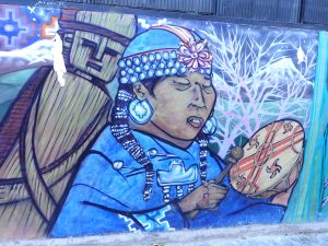 the opposition. About 3,000 people were killed, 80,000 interned and 30,000 were subjected to cruel torture. Until today, families of young people arrested several decades ago are unable to determine their burial places, hence frequent street demonstrations.
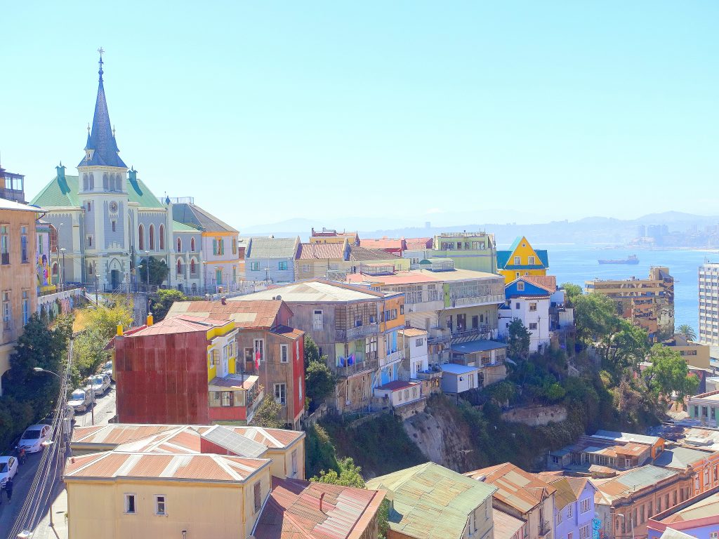
After finishing the VIPERA cosmetics training and getting to know some interesting places in the capital, under the leadership of Monika I visit the famous port of Valparaiso, considered by many as the most colorful port in the world. In 2003 UNESCO included it on the world heritage list.
This place inspires many artists and writers. One of them was the poet Pablo Neruda, who received the literary Nobel Prize for his work. Traveling from the hot capital to the coast takes only an hour. There are narrow streets here winding around the many hills of Valparaiso, called cerro.
Some of the hills can be reached with special terrestrial lifts. A hundred-year-old funicular railway is an attraction. Valparaiso has always been a city of artists, and today „street art” takes the lead here. Every now and then you can find larger and smaller murals and graffiti, representing native people, abstract forms, and more ambitious artistic messages referring to the local culture.
Next day we fly north by local airlines, to Calama, and from there 106 kilometers by bus to San Pedro, from where we will start exploring the famous Atacama Desert in the northern Chilean Andes.
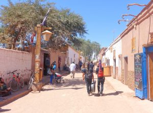
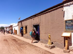
San Pedro de Atacama, overlooking the dominant Licancabur volcano, is a charming town located on a dry plateau in the Andes, in north-eastern Chile. It was founded in the mid-sixteenth century by the Spanish conquistadors. Globetrotters from all over the world come here, and rest in a green oasis at 2410 meters above sea level prior to their desert expedition. Permanent residents live in mud huts made of sun-dried bricks, erected around a colonial style church. The town is surrounded by desert, volcanoes, simple salt block buildings, geysers and hot springs.
San Pedro belonged to Bolivia until Chile gained ownership as a result of the victorious Pacific War in 1884, after which Bolivia lost the Atacama province and access to the Pacific Ocean.
From San Pedro de Atacama I took off with Monika to explore the attractions of the surrounding area. The stony and sandy Atacama Desert is a vast place which, thanks to its landscapes, takes us to another dimension. The wild beauty of the Atacama belt stretches along Chile for over 900 kilometers between the Andes and the Pacific. It occupies a total of 363,000 square kilometers and belongs to the driest places on our planet. Climatologists refer to the central part of Atacama as an absolute desert. There are barren tracts of land there where it has never rained. In 1971, for the first time in 400 years rainfall was recorded in some areas of Atacama. Atacama is located on a latitude similar to Kalahari, but it is considerably colder than the African desert. Towards the west, Atacama turns into an alpine desert. It is called Puna de Atacama.
Cordillera de Domeyko is the western range of the Andes. This is a seismic area, which is the result of the Pleistocene volcanic activity that has survived to modern times. Numerous, sometimes catastrophic earthquakes are a constant threat here. Cordillera Domeyko is the mountain range whose peaks rise to 4,260 meters above sea level. It was named after a Polish engineer Ignacy Domeyko (1802-1889), a professor at the University of Santiago. He was one of the pioneers of scientific research on the territory of Chile.
Between the high ranges of the Western and Eastern Cordillera there are numerous landlocked valleys, with large salt pans.
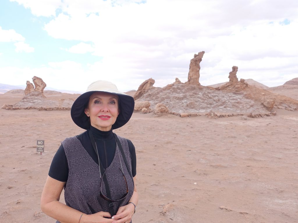
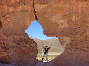
The Lunar Valley (Valle de la Luna) is famous for its truly lunar landscape. It is a depression with unusual rock formations, huge sand dunes, and pink mountain ranges. The unusual terrain sculpture and the mesmerizing shapes of sedimentary rocks were created by erosion. Millions of years ago there was a huge salt lake here. It is believed that around 300 million years ago the present area was completely flat. About 26 million years ago, tectonic plate movements caused earthquakes which in turn led to the formation of four mountain ranges in these areas. With the warming of the climate the glaciers in the Andes began to melt, and the water flowing down met Cordillere de Domeyko on its way. For hundreds of thousands of years it boiled in the valley, simultaneously forming the Death Valley. It is fascinating that there was once water in a place that is now an outright rocky wasteland.

Death Valley (Valle de la Muerte) is characterized by the lack of any forms of life. The reason for it is the high content of salt deposits and almost complete lack of moisture, which makes this place one of the most inhospitable places on the globe.
The local sands here contain rich mineral deposits, mainly iron, copper, lead and uranium ores, but also cobalt, gold, silver and rock salt. The vast terrains of the Atacama Desert belong to the world’s richest mineral sources. Sodium nitrate, the famous Chilean saltpeter mainly used as a mineral fertilizer, preservative and component in the production of nitroglycerine, is the main wealth of this region. In addition to the shepherds of llamas, the desert is inhabited by miners employed to extract saltpeter and other natural resources of the region.
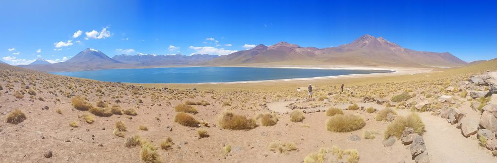
There it is, Laguna Miscanti shimmering with shades of green, azure and slightly more logical in this area sand shades.
Laguna Miscanti is a brackish lake located in the altiplano region of Antofagasta, in northern Chile. The flow of lava from the eruption of the Miñiques volcano separated Lake Miscanti from Lake Miñiques. The lake is part of one of the seven sectors of Los Flamencos National Reserve.
The Hito Cajón border crossing (4480 meters above sea level) from Chile to Bolivia is located in a pass surrounded by the massive Licancabur and Juriques volcanoes. Here, Bolivian drivers were waiting for us with off-road vehicles, which were our mean of transportation. There was also a breakfast prepared by the driver, lined up on tourist tables. We could brew coca tea for warming up — the chill was overwhelming — and as an antidote for altitude sickness. Before taking off, the driver placed on the roof a protective tarp and wrapped it around the luggage of his six passengers.
We set off through the salt desert crossed by colorful lagoons. The road seemed flat, and yet we were on gradually increasing altitude. The slopes of the ubiquitous mountains created an unreal contrast with the sandy desert landscape covered only by tufts of pale green grass.
We were not able to take eyes off the surrounding countryside at the foot of the inactive Licancabur volcano, rising at 5,920 meters above sea level. The Licancabur volcano, with its almost perfect cone shape, holds in its crater one of the highest ice-bound lakes on Earth.
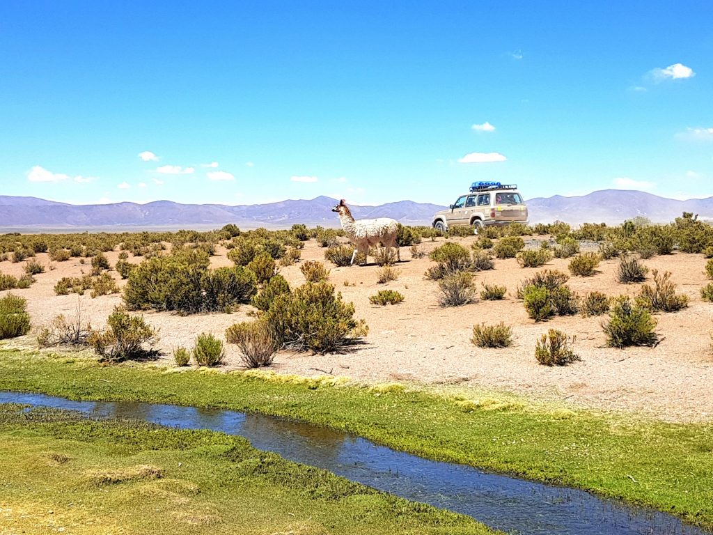
We enter the Altiplano, in literal translation: the plateau. It is a vast mountainous region in the Central Andes. The second largest – after Tibet – plateau of the world placed in the area of Peru, Bolivia, Chile and Argentina, surrounded by the Cordillera ranges, is a wavy plateau 200 kilometers wide and extending over a length of 800 kilometers. The endless space and silence, peculiarities of the natural world and the beauty of landscapes make this region a real miracle of nature. The climate on the Altiplano plateau is quite stable, but daily temperature is subject to considerable fluctuations. During the day it can reach a maximum of 25 °C, but at night it falls to as low as -10 °C.
Landscapes are amazing. And surreal. White peaks, contrasting with the saturated, almost navy blue sky and green grasses in a small pool serving as an oasis for flamingos and vicuñas — the smallest and highest living camelids – grow from the huge sand dunes. Contrary to appearances, the most dry place on earth is not devoid of life. The pale colors of vegetation surprise with their vitality. We not only came across vicuñas and llamas, but also grazing ostriches and condors.
The Andean Fauna Eduardo Avaroa natural reserve, named after the 19th century Bolivian hero, is located in Bolivia at an altitude from 4,200 meters to 5,400 meters. It stretches 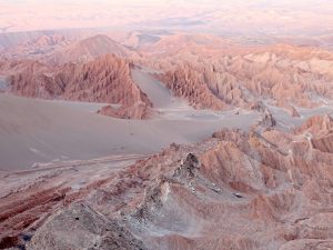 over an area of 715 hectares. The plants and animals found here are subject to strict protection. Until recently, vicuñas were threatened with extinction because of their wool, which became a luxury object of trade. Those animals shed their fur only once every three years, and they must be provided with special breeding conditions.
Sand dunes are changing into gravelly, stony planes, and these are transforming into fragile rock formations. The earth shimmers with all shades of aridity, from the sun-scorched, clear sand, through dried rock, to grey, almost black ashes flowing down the gentle slopes into dazzling white saltpans with azure lagoons.
With our eyes we eat up the volcanoes, hot springs, lagoons, mountains. We drive to the altitude of 4,800 meters, in the middle of the Sol de Manana geothermal field, to see an amazing landscape — a swampy, bubbling, steaming subsoil covered with sulfur efflorescence, and a bit further a pillar of cold steam bursting out of the mouths of volcanic chimneys. Geysers are ferociously erupting from the hot springs.
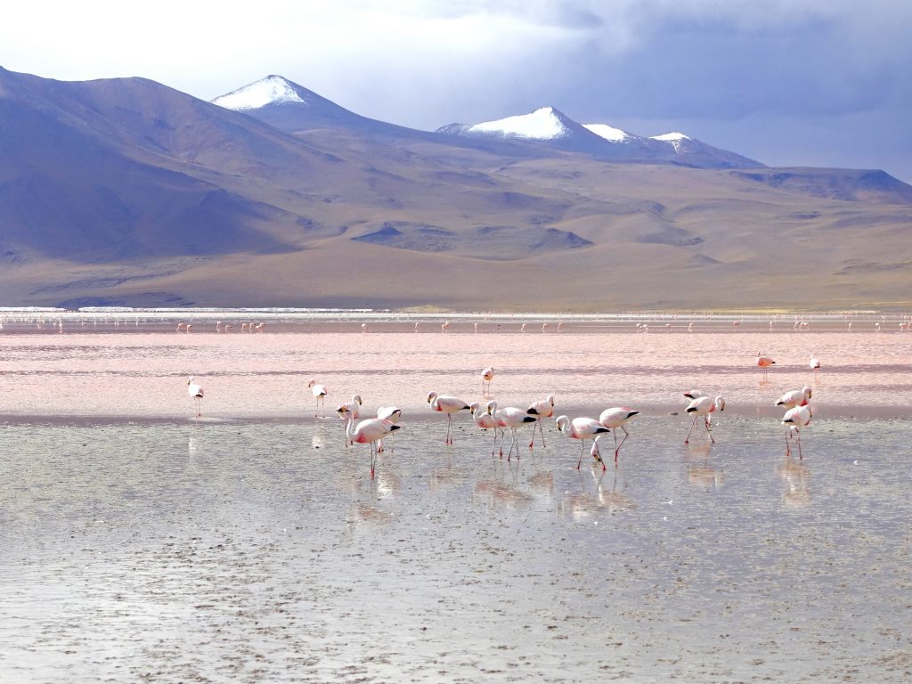
The soaring volcanoes, some of them active, with snow-covered peaks up to 6,000 meters, contrast with the magic of the blue sky. The lower areas are occupied by lagoons – salt lakes with tinted water color. Those are surrounded by numerous herds of vicuñas and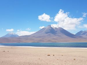 flocks of flamingos seeking food in fertile waters. Hot springs, geysers, salt lakes, borax islands and cold winds are elements of inanimate nature, which south-western Bolivia is known for.
The lagoon filled with hundreds of pink short-beaked flamingos is known as the Laguna Colorada. This picturesque, red Bolivian lake is one of the most beautiful corners of our planet. It owes its unusual color to algae and other microorganisms living in the pool. It attracts flocks of three endemic species of pink short-beaked flamingos, which are considered typical but unfortunately endangered specimens of high-mountain fauna, similarly to alpacas bred by Bolivian highlanders. On the surface of the Laguna surface we see multiple contrasting, white stretches of borax. This whole extraordinary phenomenon is integrated into a picturesque, unpolluted, mountainous landscape.
Nature has graced us here with a multi-colored spectacle; red (e.g. Laguna Colorada), turquoise, green (e.g. Laguna Verde) and light blue (e.g. Laguna Blanca). The landscape is enriched by surrounding mountains, partially extinct volcanoes and hot steam-bursting geysers. The remarkable landscape around makes it hard to believe that you are still on Earth. It seems easier to believe that we went on an interplanetary journey.
Contrasting with the blue sky, green Laguna Verde owes its color to the compounds of magnesium and arsenic, located in salt water. The color of the lake turns from turquoise to dark emerald, depending on the concentration of minerals that we can find on its bottom.
Laguna Blanca with a bright sheet and Laguna Verde with emerald waters, powered by active hot springs, contain high amounts of potassium and lithium, which are necessary for the production of computers.
The region of colorful lagoons is located on a plateau at an altitude of over 4,000 meters.
The Black Lagoon was difficult to reach. The uncanny height of 5,000 meters above sea level and the unpleasant ailments associated with it at times obscured our clarity of vision and it was sometimes hard to catch a breath while climbing the rocks, but the extraordinary Laguna fully compensated us for our efforts when the tall ridge stretched before us with an unbelievably beautiful, unforgettable view.
Intact, lunar landscapes. Magnificent, large and small lagoons which we haven’t yet experienced, boosted our imagination. The desert, whose surreal formations and colors shaped by the wind evoke painterly associations, is called the Salvador Dali Desert. The red rocks contrast with snow-white salt planes, colorful lagoons, yellow grasses and blue sky.
The landscape stretching over hundreds of kilometers offers a wealth of extraordinary aesthetic experiences and the chance to familiarize oneself with the native cultures of Quechua and Aymara.
Salt lakes and deserts are an unforgettable sight. However, what appears in front of our eyes the next morning is from a different planet altogether. As if it should not be here, like a joke, a farcical whim of the creator.
High up in the Andes, on the vast Altiplano plateau there is an unusual site – Salar de Uyuni. It is the world’s largest salt desert, which periodically turns into a salt lake. The mirror-like Salar de Uyuni lake, located at an altitude of 3,653 meters above sea level, covers an area of 10,582 square kilometers — which makes it the largest salt pan in the world. It is a remnant of the prehistoric Minchin lake which existed during the Pleistocene era about 40,000 years ago, in the northern part of the Andean Cordillera. Due to climatic and geological changes the lake dried up, leaving behind a great barrenness. The surface of the salt pan is covered by a crust, the thickness of which reaches up to 15 meters. Below it – an extraordinary treasure which is the object of desire of great world corporations. Besides the undeniable tourist values, Salar de Uyuni is a huge source of sodium, potassium, magnesium, and the world’s largest deposits of lithium, which is used on a large scale in the electronics and automotive industries, among others. It is estimated that 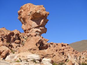 Bolivia has more than 10 million tons of lithium, 50-70% of the world’s resources. Due to that, Salar de Uyuni became a tasty morsel for foreign investors. In the era of galloping technology, manufacturers of mobile phones and laptops outdo each other in offering their customers the most modern equipment. Thanks to lithium, it has become possible to produce increasingly lighter batteries which are able to provide energy for a long time without the need of recharging. The same applies to hybrid engines, which owe their performance to the use of specially constructed batteries. So far, the Bolivian government has been very cautious about their stand towards the extremely interested in mining lithium in these areas corporations.
This attitude of the Bolivians has its roots in the historical events they experienced. With the discovery of the New World, the conquistadors treated natural resources found here as a source of their income, which flowed in a wide stream to Europe. This process was long-lasting and destructive to the native population. Therefore, the Bolivian government sends a clear message that access to lithium deposits will be very limited for foreign enterprises. Hopefully this magnificent landscape will survive all economic storms and overcome the greed of large corporations while the Bolivian government preserves these wonders of nature for future generations.
At this time of year, the salt desert in Bolivia is under a thin layer of water, which gives the effect of mirroring the sky. It is also one of the flattest areas in the world – the elevation fluctuation is only 41 centimeters.
On the high Andes plateau, at an altitude of over 4,000 meters above sea level, one comes across small villages where timeless traditions persist in extreme and wonderfully photogenic settings.
On the route to Chile we pass the vast fields of quinoa. It has been cultivated in South America for 5,000 years. Quinoa was worshipped and treated in the Inca state as a holy 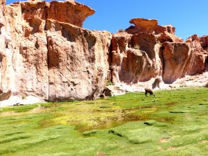 food. It was also called ‘the mother of all seeds’. Besides the seeds, leaves were eaten too, known as “Andean spinach”. Quinoa was not appreciated by the Spanish invaders who destroyed the plantations, considering them to be associated with pagan rituals. It is not until today that nutritionists have rediscovered the great qualities of these small seeds, insensitive to harsh environmental conditions, tolerating drought, and lenient to various soil types. Quinoa is easy to digest and does not contain gluten, it is beneficial for the health and figure. It has healing and anti-inflammatory properties, and reduces the risk of cancer, especially colon cancer.
Atacama delights travelers with its beauty, intrigues researchers of ancient civilizations with its remains of pre-Columbian culture, and encourages biologists to research its dry and salty land. In 2002, the Paranal Residencia complex was built here. It is used to collect information about the universe. Signals from space are registered here, for example from the depths of dust and gas which give beginnings to stars, planets and galaxies.
Atacama is a great natural phenomenon. Every place – endless expanses of sand, green valleys, blue lagoons and austere mountain peaks delight with their untainted beauty.
We take a farewell photo with a befriended group of people from Chile, France, Spain, Brazil and Poland by the Dakar rally memorial near the salt hotel in Uyuni. I think we were an interesting, spontaneous and fun team, through the best and testing moments alike. The Bolivian desert, despite its stunning charms, was an occasionally harsh experience.
We are leaving this place with the unanimous conviction that Atacama is an astounding natural wonder, and its untamed beautiful land deserves to be considered the heartbeat of South America.


